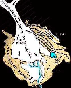
Geology
During the Glacial Period of the Quaternary, alpine
glaciers from Aosta Valley extended and reached the north-west corner of the Piedmont
plains where they formed a complex system of embankments with the eroded
drifts: the morainal amphitheatre of Ivrea. The territory which Bessa belongs
to, extends from the point where the high Biella plains connect with the two
most external morainal edges of the system: the Donato- Mongrando moraine which
starts at the southern slopes of Colma of Mombarone and ends in Mongrando (but
originally it probably extended towards SE and surrounded Bessa on the external
side) and a second one which extends towards NW-SE between Bornasco and
Vermogno, where it probably interrupts, and then it reappears again in Cerrione
in the form of little strips. The deposits were erected during the oldest
Glacial Age that can be documented in this sector (about 800000 years ago).
When the direct influence of the glacial phases ended during the high part of
the middle Pleistocene, in the external sector of the amphitheatre the
superimposition of the hydrographic network occurred, and a generalized erosion
phase started. The stream Viona dismantled some glacial deposits in the
Bornasco unit that occupied the entire area thus leaving as single wreck the
Bornasco -Vermogno moraine. In this context erratic blocks were released from
the drifts and now stud hillocks and troughs.
The local erosion and resedimentation of the deposits
belonging to the first glacial phase produced a concentration of the already
present gold. The gold contained in these deposits appears as lamellae and
granules: the granule shape indicates the low transport level it underwent by
means of the streams; in fact the granules undergo continuous percussions
between the pebbles and thanks to their high malleability they sharpen getting
a lamella shape; so most of the path from primary mines of Val d'Ayas took
place on a glacial surface. The following evolution to the forming of the place
involves the shaping of the new surface of the terrace with the formation,
thanks to the streams, of the slopes bounding it on 3 sides. Bessa now appears
as a narrow river terrace expanding on the extension of Viona Valley for over 7
km towards NW-SE, wide between a few hundred meters to a maximum of 1.1 km,
descending from about 400 m NW to 300 m SE. On the right it is delimited by the
Bornasco -Vermogno moraine and by a not very prominent shelf towards the
Olobbia stream valley and on the left, with a high slope, by the Elvo plains.
Almost the whole surface of the terrace (4.5 km2) is
covered with piles of pebbles produced by washing the roughest part of the gold
river deposits (where the sign of the settlement and the water distribution
plant are still visible) while the finer fraction (little pebbles, shingle,
sand) was led into artificial channels and resedimented at its mouth forming a
sequence of cones also included in the Special Nature Reserve founded in 1985.
Franco Gianotti
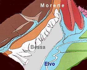
Geological map of Bessa
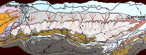
- Sup. Terrace (placer) Inf. Terrace (alluvial cones)
-Moraine Bornasco-Vermogno Moraine Donato-Mongrando
Escarpment (Dora Baltea
alluvial deposits) Recents alluvial deposits
FrancoGianotti